
Page 68 - รายงานการประยุกต์ใช้ฐานข้อมูลการสำรวจระยะไกลจากซอฟต์แวร์รหัสเปิดและคลาวด์คอมพิวติงเพื่องานพัฒนาที่ดิน Utilization of Remote Sensing Database derived from Open-source software and Cloud computing platform for Land Development
P. 68
ห้องสมุดกรมพัฒนาที่ดิน
60
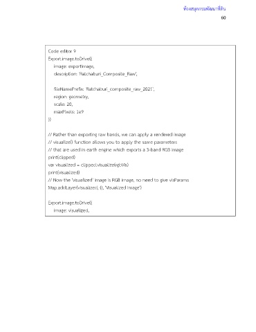
Code editor 9
Export.image.toDrive({
image: exportImage,
description: 'Ratchaburi_Composite_Raw',
fileNamePrefix: 'Ratchaburi_composite_raw_2021',
region: geometry,
scale: 20,
maxPixels: 1e9
})
// Rather than exporting raw bands, we can apply a rendered image
// visualize() function allows you to apply the same parameters
// that are used in earth engine which exports a 3-band RGB image
print(clipped)
var visualized = clipped.visualize(rgbVis)
print(visualized)
// Now the 'visualized' image is RGB image, no need to give visParams
Map.addLayer(visualized, {}, 'Visualized Image')
Export.image.toDrive({
image: visualized,
description: 'Ratchaburi_Composite_Visualized',
folder: 'earthengine',
fileNamePrefix: 'Ratchaburi_Composite_Visualized_2021',
region: geometry,
scale: 20,
maxPixels: 1e9
})