
Page 67 - รายงานการประยุกต์ใช้ฐานข้อมูลการสำรวจระยะไกลจากซอฟต์แวร์รหัสเปิดและคลาวด์คอมพิวติงเพื่องานพัฒนาที่ดิน Utilization of Remote Sensing Database derived from Open-source software and Cloud computing platform for Land Development
P. 67
ห้องสมุดกรมพัฒนาที่ดิน
59
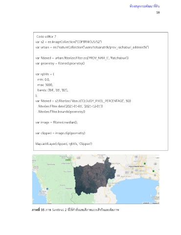
Code editor 7
var s2 = ee.ImageCollection("COPERNICUS/S2")
var urban = ee.FeatureCollection("users/totsanatrtk/prov_rachaburi_addmin56")
var filtered = urban.filter(ee.Filter.eq('PROV_NAM_E', 'Ratchaburi'))
var geometry = filtered.geometry()
var rgbVis = {
min: 0.0,
max: 3000,
bands: ['B4', 'B3', 'B2'],
};
var filtered = s2.filter(ee.Filter.lt('CLOUDY_PIXEL_PERCENTAGE', 30))
.filter(ee.Filter.date('2021-01-01', '2021-12-01'))
.filter(ee.Filter.bounds(geometry))
var image = filtered.median();
var clipped = image.clip(geometry)
Map.addLayer(clipped, rgbVis, 'Clipped')
var exportImage = clipped.select('B.*')
Export.image.toDrive({
image: exportImage,
description: 'Ratchaburi_Composite_Raw',
fileNamePrefix: 'Ratchaburi_composite_raw_2021',
region: geometry,
scale: 20,
maxPixels: 1e9
})
ภาพที่ 35 ภาพ Sentinel 2 ที่ใช้ค าสั่งผสมสีภาพแบบสีจริงและตัดภาพ
// Rather than exporting raw bands, we can apply a rendered image
// visualize() function allows you to apply the same parameters
// that are used in earth engine which exports a 3-band RGB image
print(clipped)