
Page 67 - รายงานการสำรวจดินและสภาพการใช้ที่ดิน ศูนย์ศึกษาการพัฒนาอ่าวคุ้งกระเบนอันเนื่องมาจากพระราชดำริ ตำบลคลองขุด อำเภอท่าใหม่ จังหวัดจันทบุรี
P. 67
ห้องสมุดกรมพัฒนาที่ดิน
58 ร า ย ง า น การส�ารวจดิน
ระดับน�้าใต้ดิน มำกกว่ำ 2 เมตร ในวันที่เก็บตัวอย่ำงดิน
สภาพน�้าท่วม -
การจ�าแนกดิน Sandy, siliceous, isohyperthermic, Typic Haplorthods.
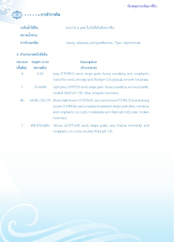
3. ค�าบรรยายหน้าตัดดิน
Horizon Depth (cm) Description
(ชั้นดิน) (ความลึก) (ค�าบรรยาย)
A 0-15 Gray (7.5YR5/1) sand; single grain; loose; nonsticky and nonplastic;
many fine roots; strongly acid (field pH 5.5); gradual, smooth boundary.
E 15-60/80 Light gray (10YR7/1) sand; single grain; loose; nonsticky and nonplastic;
neutral (field pH 7.0); clear, irregular boundary.
Bh 60/80-150/170 Mixed dark brown (7.5YR3/3), very dark brown (7.5YR2.5/2) and strong
brown (7.5YR4/6); sand; massive breaking to single grain; firm; nonsticky
and nonplastic; no roots; moderately acid (field pH 6.0); clear, broken
boundary.
C 150/170-200+ Yellow (2.5Y7-6/8) sand; single grain; very friable; nonsticky and
nonplastic; no roots; neutral (field pH 7.0).