
Page 173 - การศึกษาลักษณะและสมบัติของดินที่มีวัตถุต้นกำเนิดจากหินแกรนิตบริเวณจังหวัดอุทัยธานี
P. 173
ห้องสมุดกรมพัฒนาที่ดิน
135
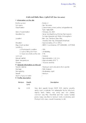
คําอธิบายหนาตัดดิน พีดอน 2 ชุดดินบานไร (Ban Rai series)
I Information on the site
Profile symbol : Pedon 2
Soil name : Ban Rai series
Classification : Coarse-loamy, mixed, active, isohyperthermic
Typic Haplustalfs
Date of examination : February 20, 2014
Described by : Danai Sanchanthong, Krishna Rammasoot,
Pochara Ariyaskul and Meta Srithongkhum
Location : Ban I Le, Tumbon Chao Wat,
Amphoe Ban Rai, Changwat Uthaithani
Elevation : Approximately 271 m (MSL)
Map sheet number : 4839 II Coordination: 47P 0545038E, 1673736N
Landform
1. Physiographic position : hills
2. Surrounding land form : Undulating
3. Slope on which profile site : 9 %
Land use : Cassava
Annual rainfall : Approximately 1,141 mm
๐
Mean temperature : Approximately 29.5 C
Climate : Tropical savanna
II General information on the soil
Parent material : Residuum and colluviums from granite
Drainage : Well drained
Permeability : Moderately rapid
Runoff : Medium
Depth of ground water : -
II Profile description
Horizon Depth Description
(cm)
Ap 0-18 Very dark grayish brown (10YR 3/2); slightly gravelly
sandy loam; moderate fine subangular blocky structure;
slightly hard, friable, non sticky and non plastic;
common very fine interstitial and few coarse tubular
pores; many very fine to medium roots; moderately acid
(field pH 6.0); clear, smooth boundary to AB.